
Southeast US
Sequential Villages and Settling Down on the Southeast U.S. Coast
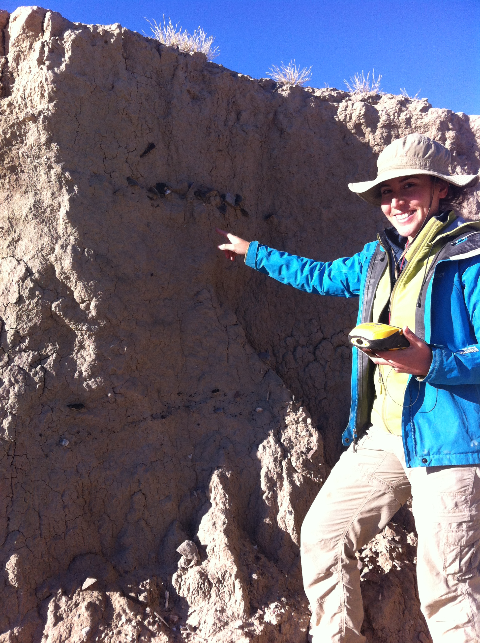
The adoption of more sedentary residential practices is a long process in which groups shift in size, permanence, makeup, and even location in response to the social, demographic, ecological, and subsistence pressures associated with settling down. Coastal peoples living in the Southeast U.S. are among the first to adopt more sedentary lifeways in North America as evidenced by their creation of dozens of large circular or arcing shell middens during the end of the Middle Holocene and start of the Late Holocene. Relying on material culture studies and AMS radiocarbon data refined using Bayesian statistical modeling, we investigate the sequential establishment and abandonment of three village sites built over more than 300 years and located only a few kilometers apart. These studies reveal important insights into the process of adopting more sedentary practices in the region and how local communities adapted to associated pressures. Link to full article here: https://doi.org/10.3389/fhumd.2024.1358614
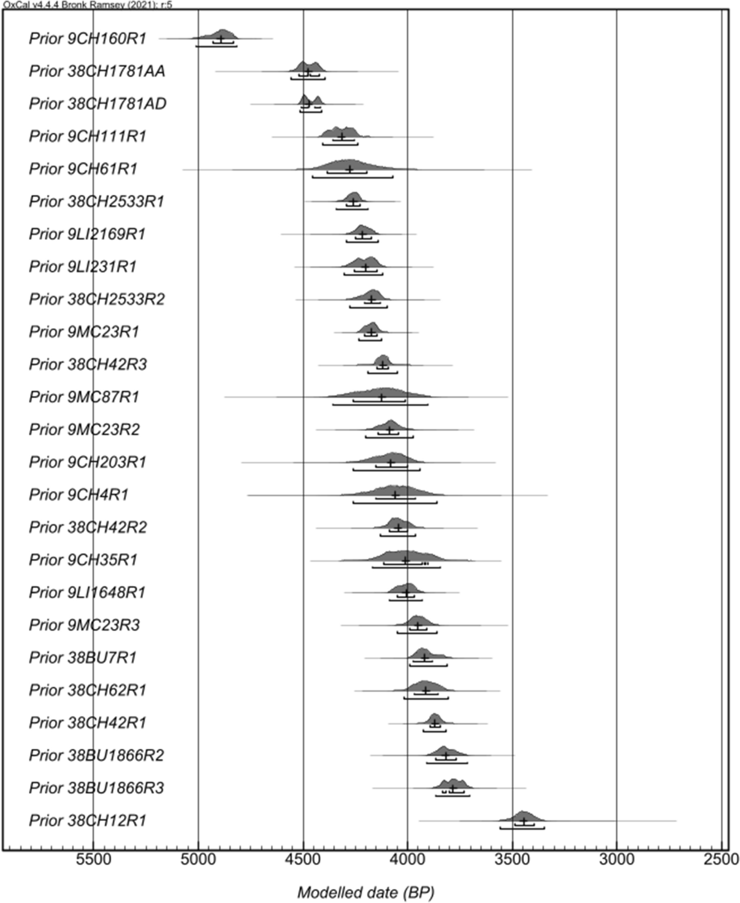
We present new chronologies that inform the timing and tempo of shell ring and shell mound construction on the South Atlantic Bight. Our project combines recently acquired dates with legacy radiocarbon dates from over 25 rings and mounds to provide a higher-resolution chronology regarding the occupation and formation of this larger landscape of the earliest fishing villages along the East Coast of the United States. We resolve the ordering and timing of occupation of these rings and mounds through Bayesian statistical modeling. These new models historicize and contextualize these shell rings in ways previously impossible. Specifically, our new chronologies of these villages indicate that the earliest villages were established prior to the invention of pottery. The early period of village establishment evidences isolated village rings, whereas later periods seem to have more villages, but these appear to have been relocated to other areas and/or islands over time. Shell mounds are fewer in number, are spread throughout the time period, and may represent special purpose sites compared to shell-rings. Once villages spread, they quickly adopted new technologies (i.e., pottery) and created new institutions and practiced village relocation, which allowed this way of life to persist for more than a thousand years. Link here to article: https://doi.org/10.1038/s41598-024-55047-z
Collaborative multimethod geophysics at the Prewitt Slave Cemetery, Northport, Alabama
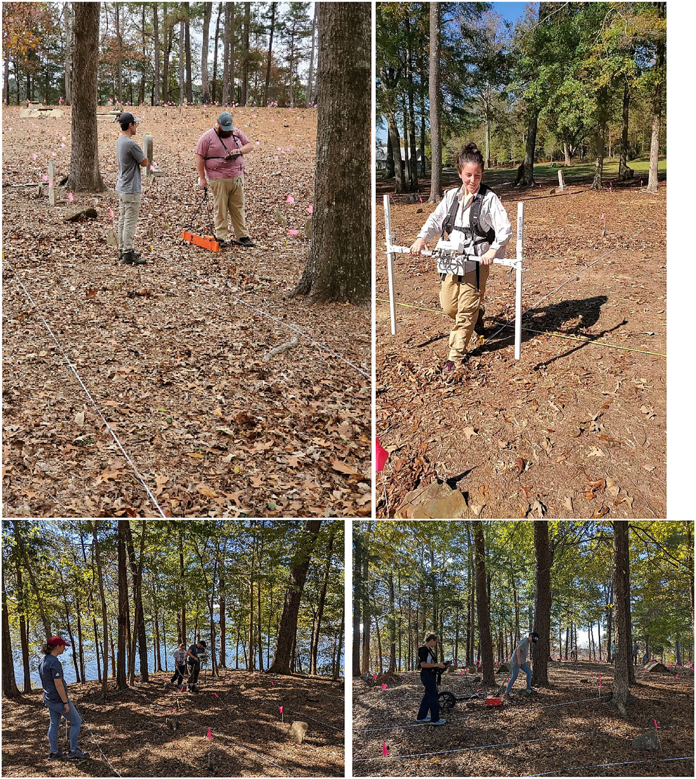
This paper serves to highlight the partnership built between the Prewitt Slave Cemetery Association (PSCA) and the University of Alabama (UA) through the work conducted by the UA archaeological field school at the Prewitt Slave Cemetery (PSC) in Fall 2022. During this collaborative project, the field school students geolocated, recorded, and photographed more than 700 hundred above-ground grave markers and conducted a multi-method geophysical survey which included magnetic gradiometry, electrical resistance, electromagnetic induction, and ground-penetrating radar. Results from this survey aided researchers in identifying the locations of over 700 marked and unmarked graves. The benefits of the partnership between PSCA and UA were mutual and multiple. First, the data recorded by the UA field school helped the PSCA achieve its immediate goal of identifying unmarked graves, allowing the organization to move forward with efforts to preserve and protect the Prewitt Slave Cemetery. Second, the UA field school students gained valuable experience related to proper cemetery study techniques, including geophysical survey, and learned to conduct community-based participatory research in collaboration with descendant communities. Additionally, this project allowed for further research related to the use of multiple methods of geophysical instrumentation for identifying unmarked graves beyond ground-penetrating radar. Link to article here : https://doi.org/10.1002/arp.1919
Air and Sound: Indigenous wind instruments made of bone in Southeast United States
By studying the distribution of wind instruments made of bone, we investigate the presence of musical traditions in the American Southeast and nearby regions during the last few centuries prior to European arrival. Our findings show that southeastern Indigenous peoples used bone instruments far less than their neighbors, suggesting that they almost exclusively made whistles and flutes from reeds, wood, and other materials that do not survive in the archaeological record. This variation in materials was not based on a lack of knowledge, as we detail the presence of several bone wind instruments in the Southeast, but rather, we suggest, a unique musical tradition in the region. Link to article here.
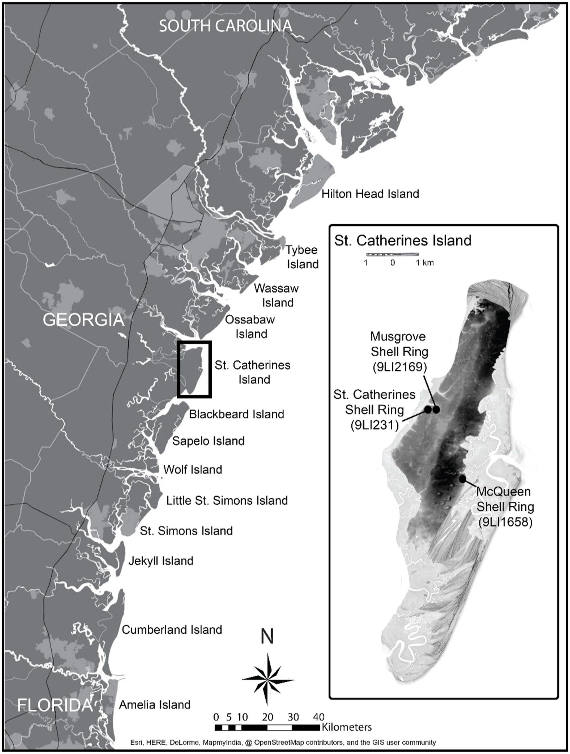
Cross-mended ceramic sherds as a proxy for depositional processes at two Late Archaic shell rings in coastal Georgia Characterizing the depositional and temporal nature of sediments lends insight into the construction of monuments and midden accumulation. Identifying discrete deposits at Late Archaic shell rings can be challenging due to the seemingly homogenous nature of shell deposits. Data from cross-mended artifacts can help identify surfaces and determine whether deposits are contemporaneous. We present cross-mend results from the St. Catherines Shell Ring and the Sapelo Island Shell Ring complex. In both cases, we observed vertical distance between cross-mends suggesting that detailed spatial control of artifacts and cross-mend analysis can be used to understand the nature of anthropogenic deposition and postdepositional processes. Link to article.
NW Mexico/SW United States
Earthen irrigation canals were an important technological development in arid lands farming. La Playa, in Sonora has evidence of an extensive irrigation canal system dating to the Early Agricultural Period (2100 BC – 50 AD). Radiocarbon dating on gastropods, charcoal, and soil humates, and Optically Stimulated Luminescence dating on canal sediments revealed two phases of canal use during this period, corresponding to favorable environmental conditions and the earliest dates on zea mays. Link to article here.
Shallow Geophysical Survey at La Playa.
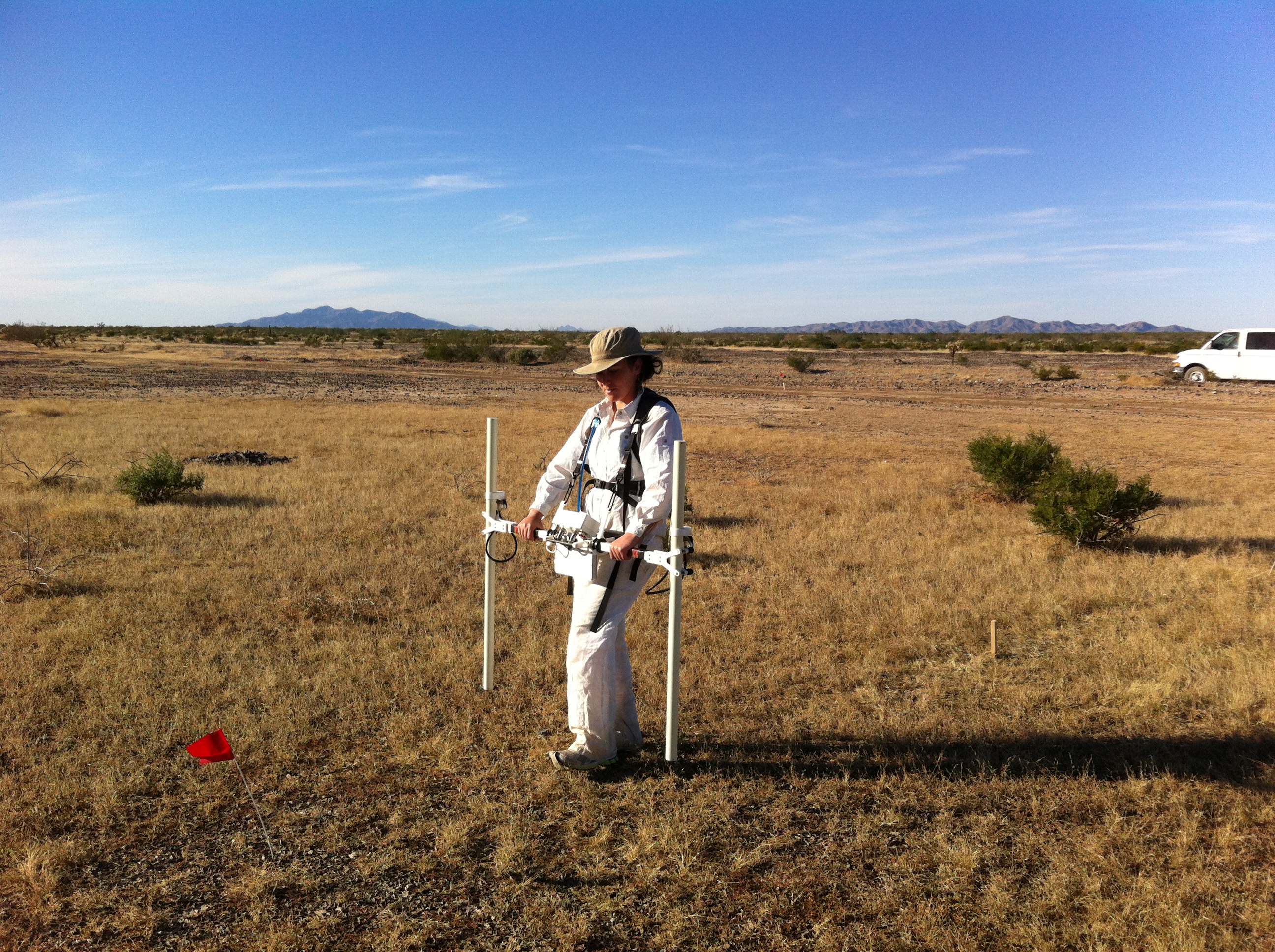
Techniques from shallow geophysical prospection can help archaeologists image various subsurface anomalies without excavation. Magnetic Gradiometry was used at La Playa in order to locate Early Agricultural Period irrigation canals. This method successfully identified buried canals, cultivation plots, and various water retentions features, thus providing insight into the technology and land management strategies of the earliest farmers of the region. Link to article here.
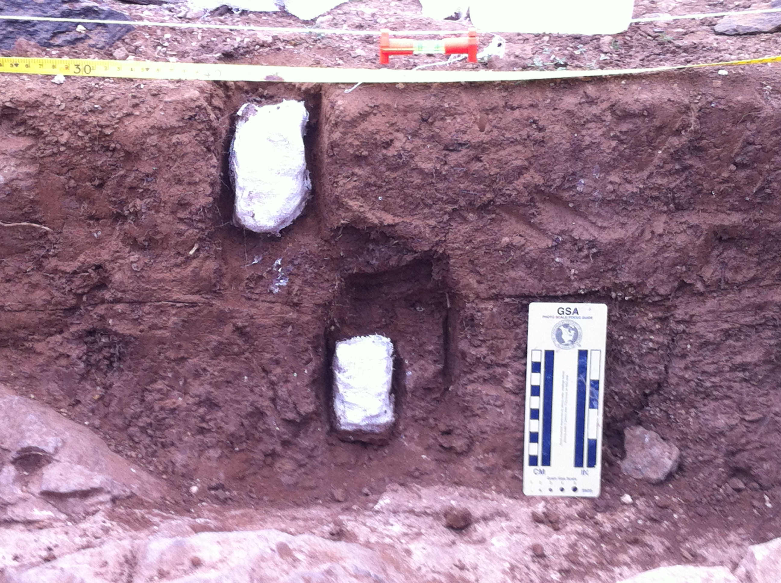
Soil Characterization and Micromorphology at Tumamoc Hill, AZ
Soils are an indicator of environmental conditions and stability of a landscape. Micromorphology is the microscopic analysis of undisturbed soils and sediments. Intact soil blocks are carefully removed and hardened with resin and epoxy. They are then cut into thin sections for microscopic analysis. The microscopic constituents of the soil tell us about the complex interactions between humans and the environment.
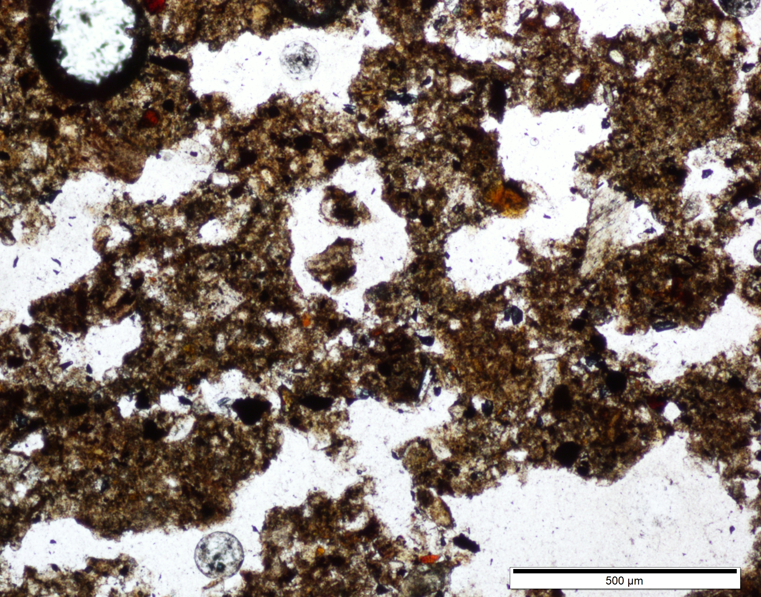
Micromorphology Analysis at Onavas, Mexico
Soil micromorphology can lend insight into the depositional processes at an archaeological site. At the El Cementerio site, a Postclassic Period (1000-1521 AD) burial mound, soil microstructure was examined in order to distinguish areas of human construction and natural deposition from the nearby Rio Yaqui.
